Scotland: Biodiversity Audits and RAMS Mapping Services
Compliant with Whole Farm Plan Biodiversity Audits
Habitat Mapping Service
Senus provides a full farm habitat map in digital formats for easy submission to the Scottish government under the Whole Farm Plan programme. We use the full list of required habitats and linear features recommended by NatureScot for habitat mapping. Broad categories include: cropped land, grassland, wetland, woodland, coastal, upland and peatland, designated/historic sites, linear features and point habitats.
Habitat Mapping Tool
This tool includes a unique “suggestion” feature where the farmer or advisor can place notes on the maps to suggest changes. The final outcome is an accurate habitat map in Picture (png) or Geospatial (Shape file) format for submission to the Scottish Government.
How Does it Work?
Step 1
You provide Senus with farm details including farm maps
Step 2
Senus creates digital habitat maps
Step 3 Maps are shared for review and feedback is actioned
Step 4
Final maps are ready for submission
Helping Scottish Farmers Spread Responsibly with RAMS Maps
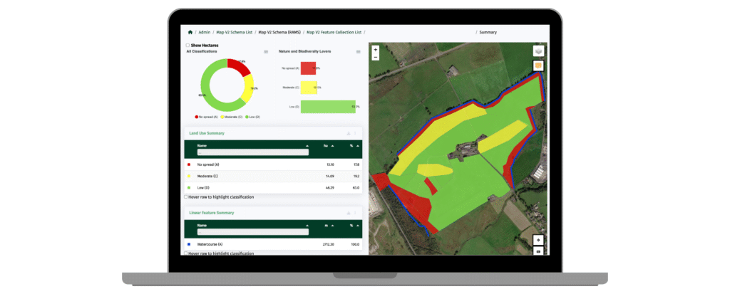
At Senus, we’re supporting Scottish agriculture with our RAMS (Risk Assessment for Manure and Slurry) Maps – practical tools designed to make nutrient and waste management easier, safer, and compliant.
A RAMS Map assesses land suitability and identifies pollution risks when spreading slurry or manure. Each map clearly highlights:
No‐spread zones
Areas of spreading risk
Best‐practice guidance for contractors and farmers
These maps are fully compliant and align with Scotland’s environmental standards, helping you demonstrate good farming practice while protecting watercourses, soil health, and your business reputation.
A RAMS plan can also form part of your Nutrient Management Plan and Farm Waste Management Plan (FWMP) – giving you a complete, evidence‐based approach to responsible land management.
We are delighted to be a member of Scottish Land & Estates.
Talk to Imogen today to find out more
Connect with one of our experts today to discover how Senus’s habitat mapping service and tailored RAMS Maps can work together to keep your farm compliant, efficient, and environmentally sound.